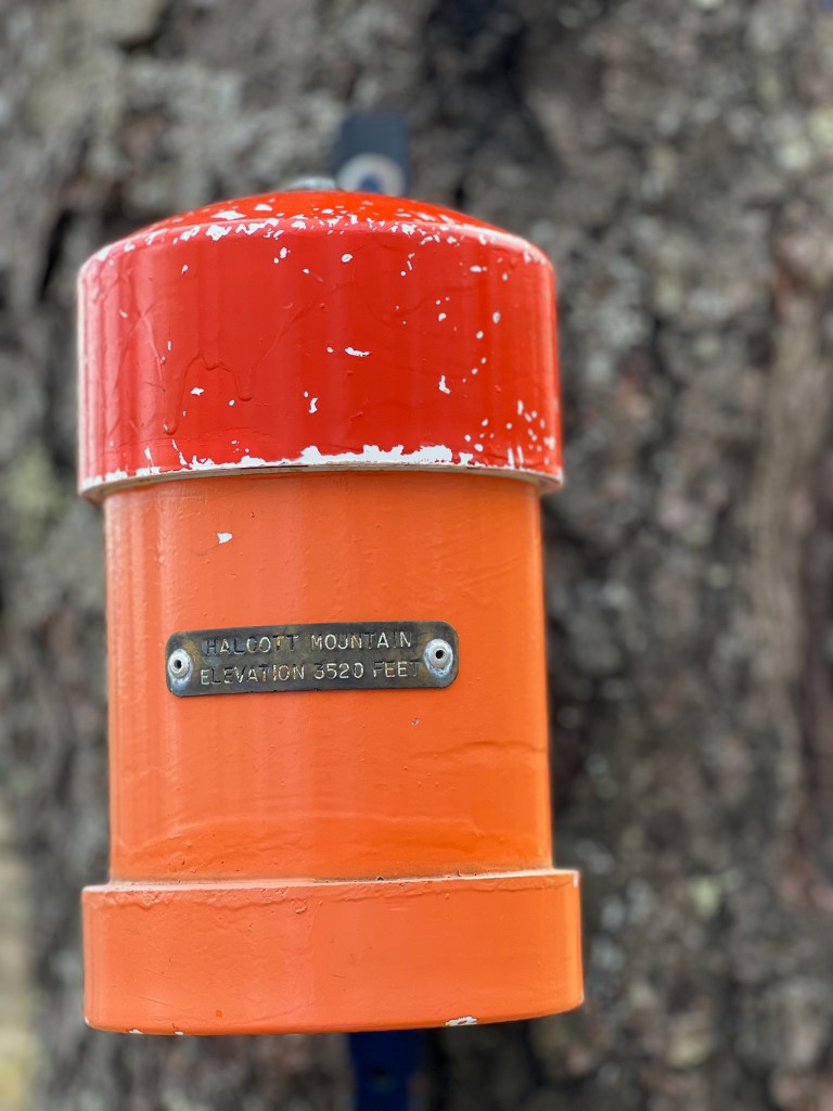
Two of the higher trailless peaks in the Catskills, Sleeping Lion Mountain (3391′) and Halcott Mountain (3509′) are accessible from Route 42 in the north central region of the Catskill Park. Halcott Mountain is one of the Catskill 3500 Peaks, while Sleeping Lion is part of the Catskill Hundred Highest peaks.
Besides being on these peak lists, there isn’t a whole lot to attract folks to these mountains. There are few, if any, views. Especially in the summer months, the undergrowth of nettles and thorns can get pretty gnarly. That said, putting them together as a 6.5-mile bushwhack loop makes for some good exercise along the way. And I’ve always found exploring our mountains, above and beyond any list-making, to be a rewarding trip unto itself.
The most straightforward route to bushwhack these two trailless peaks is to create a loop over both peaks that begins at the parking lot located on Route 42 in Deep Notch. From the parking lot a distinct herd path climbs up and past the nearby waterfall (on the right of the waterfall) and then continues across the creek at the top of the water to left and ascends Halcott. You could do the loop either way (clockwise or counterclockwise).
For this trip, I went the counterclockwise way, which begins with an ascent up Sleeping Lion, so instead of following the herd path to the left, I turned right and followed the ridge to the summit of Sleeping Lion. From there, I followed the ridge between Sleeping Lion and Halcott to the summit of Halcott Mountain.
It’s important to note that while there is a significant and relatively easy to follow herd/social path up Halcott Mountain, for the most part the route up the ridge of Sleeping Lion and the ridge from Sleeping Lion to Halcott are herd path free and you’ll need to rely on your navigational skills.
After summiting Halcott, I spent some time looking for Halcott’s elusive vista (you can see how that turned out in the video) and then I descended via the very distinct herd path on Halcott back down to the parking area where I had began.
The hike/bushwhack is about 6.5 miles in length, with about 2250 feet of elevation gain along the way. The hike is moderate to difficult. At least half of the bushwhack is without herd paths and requires good navigation skills. Having a map and knowing how to use it, along with a compass is key. GPS or GPS apps on your phone come in handy, but the batteries can always die – so always have that paper map. There’s also no service on the majority of this hike (except for the summits of the two peaks).
###
For more information
You can find this hike on:
- The NYNJ Trail Conference’s Catskill Trails Map Set
- National Geographic’s Trails Illustrated Map for the Catskill Park
- Catskill Trails Guidebook from ADK
- Hiking the Catskills Guidebook
Additional Catskill Park information available at the Catskills Visitor Center (5096 Route 28 in Mt. Tremper)
Watch all of our Hiker Trash Husbands videos about the Catskills on YouTube
Gear I used and/or carried on this hike:
- Goodr Sunglasses
- Osprey Talon 22 Pack
- Altra Lone Peak Shoes
- Darn Tough Midweight Hiking Socks
- Black Diamond Trail Back Trekking Poles
- Patagonia Nine Trails Shorts
- EMS Men’s Essential Peak Tank
- Hiker Trash Husbands Trucker Hat
- Energizer LED Headlamp
- NEMO Chipper Reclaimed Closed-Cell Foam Seat Pad
- Nalgene 32-ounce Wide-Mouth Water Bottles
- Sawyer Squeeze Water Filter
- CNOC Vecto Water Container
- Garmin Instinct Watches
- Garmin InReach Explorer+ GPS
(Product links are affiliate links, so if you purchase something through them, it helps out)
Important Hiking Considerations:
- Weather: Check the weather forecast before your hike and be prepared for changes in conditions.
- Safety: Some sections of the route can be steep and rocky, so use caution and watch your footing.
- Leave No Trace: As with any outdoor activity, remember to follow the principles of Leave No Trace. Pack out any trash, stay on the trail, and be respectful of the natural environment.